Lesson plan introducing and exploring via hands-on lab the idea that raising …
Lesson plan introducing and exploring via hands-on lab the idea that raising acidity in the world's oceans is reducing the availability of carbonate, which impacts calcifying organisms such as oysters and sea urchins.
This resource links to a rotation-based "game" created by NOAA and the …
This resource links to a rotation-based "game" created by NOAA and the National Weather Service. I've also attached a 5E formatted lesson plan giving some background and introduction. The activity should take about one class period, and there is a point-of-view writing activity included as extension. You'll need to print out (and laminate for durability) the station cards and labels. Be sure to print the student recording sheet as well.
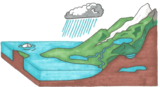
This resource is a remix of https://goopenva.org/courses/the-water-cycle-game. The water cycle game helps …
This resource is a remix of https://goopenva.org/courses/the-water-cycle-game. The water cycle game helps you learn how water molecules move through various places including rivers, the ocean, the earth’s surface, the atmosphere, and clouds. Actions such as evaporation, runoff, condensation, precipitation, soil absorption, and groundwater expansion move water from one zone to another.Modifications: This game can be played in cooperative groups or use as part of a personalized or blended learning playlist. This game has a lot of visuals and would help for those visual learners to better understand the water cycle process. Another modification would be to ask students to write a reflection about the water cycle in their own words and create a vocabulary bank. This encourages literacy in curriculum allowing students to use complete sentences with appropriate grammatical usage.
No restrictions on your remixing, redistributing, or making derivative works. Give credit to the author, as required.
Your remixing, redistributing, or making derivatives works comes with some restrictions, including how it is shared.
Your redistributing comes with some restrictions. Do not remix or make derivative works.
Most restrictive license type. Prohibits most uses, sharing, and any changes.
Copyrighted materials, available under Fair Use and the TEACH Act for US-based educators, or other custom arrangements. Go to the resource provider to see their individual restrictions.