Updating search results...

Search Resources

15 Results

View
Selected filters:
  • coordinates
6.8 Coordinate Plane Practice
Unrestricted Use
CC BY
Rating
0.0 stars

With this activity, students will review the components of the coordinate plane, graph coordinates, and tell coordinates.   This activity was created with Jamboard to allow the teacher to view students placements of points and work in real time.  The activity can be presented to the whole group with the teacher giving  students assignments on each slide (by sharing editor rights) or assigned to individual students with each a copy. 

Subject:
Mathematics
Material Type:
Activity/Lab
Author:
Melody Oquinn
Date Added:
04/06/2021
Assessing the Situation
Read the Fine Print
Educational Use
Rating
0.0 stars

Finding themselves in the middle of the Amazon rainforest after a plane crash, students use map scales, keys, and longitude and latitude coordinates to figure out where they are. Then they work in groups to generate ideas and make plans. They decide where they should go to be rescued, the distance to that location, the route to take, and make calculations to estimate walking travel time.

Subject:
Science
Scientific and Engineering Practices
Material Type:
Activity/Lab
Provider:
TeachEngineering
Provider Set:
TeachEngineering
Date Added:
09/18/2014
Coordinate Plane and Plotting Points Introduction Activity (Math-6th)
Conditional Remix & Share Permitted
CC BY-NC-SA
Rating
0.0 stars

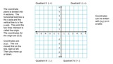
Students will identify the parts of the coordinate plane and graph ordered pairs in all four quadrants of the coordinate plane. There are strategies embedded within the handout to support an enduring understanding. For example, in order to plot points, you can use an Elevator relation: Choose the door "x", then the floor "y")
Extension: Virginia Department of Education resource document titled, "Coordinate Plane", which is a remediation lesson. Students identify, and graph ordered pairs in the four quadrants of a coordinate plane. Visual aid handout, exit ticket, and lesson plan are included.

Subject:
Mathematics
Material Type:
Activity/Lab
Assessment
Homework/Assignment
Date Added:
11/10/2019
Coordinates and the Cartesian Plane
Read the Fine Print
Educational Use
Rating
0.0 stars

A brief refresher on the Cartesian plane includes how points are written in (x, y) format and oriented to the axes, and which directions are positive and negative. Then students learn about what it means for a relation to be a function and how to determine domain and range of a set of data points.

Subject:
Science
Scientific and Engineering Practices
Material Type:
Lesson Plan
Provider:
TeachEngineering
Provider Set:
TeachEngineering
Author:
Aubrey McKelvey
Date Added:
09/18/2014
The Crash Scene
Read the Fine Print
Educational Use
Rating
0.0 stars

In this lesson, students find their location on a map using Latitude and Longitudinal coordinates. They determine where they should go to be rescued and how best to get there.

Subject:
Science
Scientific and Engineering Practices
Material Type:
Activity/Lab
Lesson Plan
Provider:
TeachEngineering
Provider Set:
TeachEngineering
Date Added:
09/18/2014
Digital Mapping and Geographic Information Systems (GIS)
Read the Fine Print
Educational Use
Rating
0.0 stars

Geographic information systems (GIS), once used predominantly by experts in cartography and computer programming, have become pervasive in everyday business and consumer use. This unit explores GIS in general as a technology about which much more can be learned, and it also explores applications of that technology. Students experience GIS technology through the use of Google Earth on the environmental topic of plastics in the ocean in an area known as the Great Pacific Garbage Patch. The use of this topic in GIS makes the unit multidisciplinary, incorporating the physics of ocean currents, the chemistry associated with pollutant degradation and chemical sorption to organic-rich plastics, and ecological impact to aquatic biota.

Subject:
Science
Scientific and Engineering Practices
Material Type:
Full Course
Unit of Study
Provider:
TeachEngineering
Provider Set:
TeachEngineering
Author:
Andrey Koptelov
Nathan Howell
Date Added:
09/18/2014
Foucault Pendulum
Read the Fine Print
Educational Use
Rating
0.0 stars

Students learn about the Foucault pendulum an engineering tool used to demonstrate and measure the Earth's rotation. Student groups create small experimental versions, each comprised of a pendulum and a video camera mounted on a rotating platform actuated by a LEGO MINDSTORMS(TM) NXT motor. When the platform is fixed, the pendulum motion forms a line, as observed in the recorded video. When the rotating, the pendulum's motion is observed as a set of spirals with a common center. Observing the patterns that the pendulum bob makes when the platform is rotating provides insight as to how a full-size Foucault pendulum operates. It helps students understand some of the physical phenomena induced by the Earth's rotation, as well as the tricky concept of how the perception of movement varies, depending on one's frame of reference.

Subject:
Science
Scientific and Engineering Practices
Material Type:
Activity/Lab
Provider:
TeachEngineering
Provider Set:
TeachEngineering
Author:
Jeffrey Laut
Violet Mwaffo
Date Added:
09/18/2014
Nidy-Gridy
Read the Fine Print
Educational Use
Rating
0.0 stars

Normally we find things using landmark navigation. When you move to a new place, it may take you awhile to explore the new streets and buildings, but eventually you recognize enough landmarks and remember where they are in relation to each other. However, another accurate method for locating places and things is using grids and coordinates. In this activity, students will come up with their own system of a grid and coordinates for their classroom and understand why it is important to have one common method of map-making.

Subject:
Science
Scientific and Engineering Practices
Material Type:
Activity/Lab
Provider:
TeachEngineering
Provider Set:
TeachEngineering
Author:
Janet Yowell
Jeff White
Malinda Schaefer Zarske
Matt Lippis
Penny Axelrad
Date Added:
10/14/2015
Projections and Coordinates: Turning a 3D Earth into Flatlands
Read the Fine Print
Educational Use
Rating
0.0 stars

Projections and coordinates are key advancements in the geographic sciences that allow us to better understand the nature of the Earth and how to describe location. These innovations in describing the Earth are the basis for everything that is done in a GIS framework. Shape of the Earth is a critical starting point because in fact the Earth is not round but rather a more complex shape called a geoid. Coordinate systems are often referenced to a particular model shape of the Earth, but many different formats exist because not all coordinates work equally well in all areas. While projections and coordinates are abstract concepts in themselves, students eventually find them interesting because 1) it causes them to challenge their current ideas of the Earth's shape and 2) it is much easier to visualize these ideas for learning through interactive GIS such as Google Earth.

Subject:
Science
Scientific and Engineering Practices
Material Type:
Lesson Plan
Provider:
TeachEngineering
Provider Set:
TeachEngineering
Author:
Andrey Koptelov
Nathan Howell
Date Added:
09/18/2014
Walk the Line: A Module on Linear Functions
Read the Fine Print
Educational Use
Rating
0.0 stars

Prepared with pre-algebra or algebra 1 classes in mind, this module leads students through the process of graphing data and finding a line of best fit while exploring the characteristics of linear equations in algebraic and graphic formats. Then, these topics are connected to real-world experiences in which people use linear functions. During the module, students use these scientific concepts to solve the following hypothetical challenge: You are a new researcher in a lab, and your boss has just given you your first task to analyze a set of data. It being your first assignment, you ask an undergraduate student working in your lab to help you figure it out. She responds that you must determine what the data represents and then find an equation that models the data. You believe that you will be able to determine what the data represents on your own, but you ask for further help modeling the data. In response, she says she is not completely sure how to do it, but gives a list of equations that may fit the data. This module is built around the legacy cycle, a format that incorporates educational research feindings on how people best learn.

Subject:
Science
Scientific and Engineering Practices
Material Type:
Unit of Study
Provider:
TeachEngineering
Provider Set:
TeachEngineering
Author:
Aubrey Mckelvey
Date Added:
09/18/2014
What Is GIS?
Read the Fine Print
Educational Use
Rating
0.0 stars

Geographic information systems (GIS) are important technology that allows rapid study and use of spatial information. GIS have become increasingly prevalent in industry and the consumer/internet world in the last 20 years. Historically, the basis of GIS was in mapping, and so it is important to understand the basis of maps and how to use them as well as why they are different from GIS. In this lesson, students learn the value of maps, how to use maps, and the basic components of a GIS. They are also introduced to numerous GIS applications.

Subject:
Science
Scientific and Engineering Practices
Material Type:
Lesson Plan
Provider:
TeachEngineering
Provider Set:
TeachEngineering
Author:
Andrey Koptelov
Nathan Howell
Date Added:
09/18/2014
Where Are the Plastics Near Me? (Mapping the Data)
Read the Fine Print
Educational Use
Rating
0.0 stars

In a student-led and fairly independent fashion, data collected in the associated field trip activity are organized by student groups to create useful and informative Google Earth maps. Each team creates a map, uses that map to analyze the results, adjusts the map to include the analysis results, and then writes a brief summary of findings. Primarily, questions of fate-and-transport of plastics are are explored. If data was gathered in the field trip but the teacher does not desire to do the mapping activity, then alternative data presentation and analysis methods are suggested.

Subject:
Science
Scientific and Engineering Practices
Material Type:
Activity/Lab
Provider:
TeachEngineering
Provider Set:
TeachEngineering
Author:
Andrey Koptelov
Nathan Howell
Date Added:
09/18/2014
Where is Here?
Read the Fine Print
Educational Use
Rating
0.0 stars

In this lesson, students are shown the very basics of navigation. The concepts of relative and absolute location, latitude, longitude and cardinal directions are discussed, as well as the use and principles of a map and compass.

Subject:
Science
Scientific and Engineering Practices
Material Type:
Activity/Lab
Lesson Plan
Provider:
TeachEngineering
Provider Set:
TeachEngineering
Author:
Janet Yowell
Jeff White
Malinda Schaefer Zarske
Matt Lippis
Penny Axelrad
Date Added:
09/18/2014