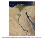
This inquiry focuses on the impact of the flooding of the Nile …
This inquiry focuses on the impact of the flooding of the Nile River on ancient Egypt, specifically the costs and benefits of the flooding. Through examination and analysis of various photographs, videos, and article excerpts, students will consider how these sources can be used to convey the impact of flooding on multiple groups of people in ancient Egypt.The questions, tasks, and sources in this inquiry asks students to learn about how Egyptian civilization grew by comparing the costs and benefits of the Nile River’s flooding. This inquiry highlights the following Virginia social studies standards.
In the second lesson of four on Ancient Greece, students refine their …
In the second lesson of four on Ancient Greece, students refine their knowledge of physical features as they investigate pictures of Greece and determine how a particular physical feature influenced human action. Key question: How did the physical geography of the Aegean basin shape the economic, social and political development of Greek civilization?
This inquiry focuses on the government of Ancient Greece, specifically the creation …
This inquiry focuses on the government of Ancient Greece, specifically the creation of the Greek democracy. The questions, tasks, and sources in this inquiry asks students to consider the meaning of democracy and whose voices were heard in the original democracy and whose were not. Through analysis of videos, photographs of ancient artifacts, political cartoons and graphs students develop an argument supported by evidence that answers the compelling question, “Was Greek democracy a success?”
In the first lesson of four on Ancient Greece, students use geographic …
In the first lesson of four on Ancient Greece, students use geographic terms such as hemispheres, continents, and direction to describe the relative location of Greece within the world, within Europe, and within the Aegean Basin. In addition, students extend and refine their ability to identify various types of physical features on maps at a variety of scales. Students examine maps to identify and describe the physical environment of Greece. Key questions: Where is ancient Greece located?; What are physical features of the Aegean Basin?; How did the location of Greece and its physical environment influence its interaction with the rest of the world?
In the third lesson of four on Ancient Greece, students simulate trade …
In the third lesson of four on Ancient Greece, students simulate trade between Greek city states and their colonies. The overall goal is for the Greek traders and colonists to travel to new territories, trade resources, and as a result build an empire and spread Hellenistic culture. Through the examination of the goods exchanged, students gain a basic understanding of specialization in the various areas of the Mediterranean Basin. Key questions: Why did the Greeks acquire colonies?; How did Greek culture diffuse throughout the Mediterranean world?; What were the effects of the diffusion of Greek culture?
In the last lesson of four on Ancient Greece, students employ spatial …
In the last lesson of four on Ancient Greece, students employ spatial thinking to understand the extent of the empire of Alexander the Great by examining and comparing visuals and maps. Key question: How does the geographic extent of an empire influence its ability to exist through time?
In the first of two lessons on ancient river valley civilization, students …
In the first of two lessons on ancient river valley civilization, students examine the physical environment of the early river valley civilizations. After identifying the locations of the ancient civilizations, students complete a feature analysis to assist them in comparing the physical environments and determining how it afforded protection to the civilizations. Key questions: Why was a river valley a good place for a settlement? What was the significance of these river valley civilizations?
In the second of two lessons on ancient river valley civilizations, students …
In the second of two lessons on ancient river valley civilizations, students examine the physical environment of the early river valley civilizations. Moving water carries and sorts sediment, changes landforms, and creates strata. The sediment becomes the base for soil formation, and it is the material of which flood plains, deltas, and natural levees are built. Through a demonstration of the sedimentation process, students will come to understand the significance of the process and seasonal flooding to agricultural activity in the early river valley civilizations. Key questions: How does the process of sedimentation affect soil fertility? Why are some river valleys good sites for human settlement?
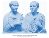
This inquiry focuses on the social hierarchy of ancient Rome, viewed through …
This inquiry focuses on the social hierarchy of ancient Rome, viewed through the lens of statues that tell us about life during this time. Through analysis of videos, photographs of ancient statues, and images of architectural reliefs, students develop an argument supported by evidence that answers the compelling question, “What stories should statues tell about ancient Rome?”The inquiry prioritizes depth over breadth: rather than broadly describe contributions across categories, the inquiry instead invites students to take a close look at the influence of ancient Roman art and architecture on statues and monuments today. Through this deep study, students will hone analytical skills required to notice and interpret details in art and architecture while also building their knowledge about the social structure that divided the citizens and enslaved people of the ancient Roman republic and empire.
The first lesson of two on Ancient Rome, students examine physical maps …
The first lesson of two on Ancient Rome, students examine physical maps of Rome to identify physical features that provided security for the site of Rome. In addition, students examine the relative location of Rome and its connections within the Mediterranean Basin and beyond. The second segment of the lesson examines the expansion of the Roman Empire through time and the role of physical features in facilitating or hindering that expansion. Key questions: What are the physical features of Rome?; How did the physical geography of Rome influence its development?
The second lesson of two on Ancient Rome, students examine the geographic …
The second lesson of two on Ancient Rome, students examine the geographic extent of the Roman Empire. The Orbis Web site, hosted by Stanford University, provides a map of the Roman Empire at its largest extent with the locations of key cities and transportation links. Key questions: How were places within the Roman Empire connected?; How did time and distance affect interactions within the Roman Empire?
This is a Round Robin review game for World History II SOL …
This is a Round Robin review game for World History II SOL 6. It covers the empires of Ottomans, Safavids, Mughals, China & Japan. This assignment template could be easily adapted for a review for another set of content material. *Also known as "I have, who has".
This unit is intended to address the VA Standards of Learning for …
This unit is intended to address the VA Standards of Learning for World History II Standards 6 and 7. Students are required to explore the similarities and differences between the various Asian land empires and African societies of the 1500s-1800s, with a particular focus on geographic, political, cultural, and economic interactions with each other and the rest of the world. Through the unit, students practice information literacy skills as they research and become experts in one Asian or African empire, work with a group to develop a virtual museum exhibit on it, and explore the virtual museum exhibits created by the other groups to learn about all of the empires and synthesize the unit content. The unit, which is separated into 6 modules, was designed for use in a virtual learning environment with both synchronous and asynchronous components. It could easily be converted to a fully face-to-face unit, but it would be challenging to convert it to a fully asynchronous online unit because of the group work activities involved.
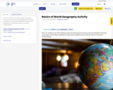
This is an activity to use with students as they are learning …
This is an activity to use with students as they are learning how to read a map and decipher continents and oceans. This activity is intended for high school students and can also be used as a check for understanding.
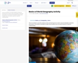
This is an activity to use with students as they are learning …
This is an activity to use with students as they are learning how to read a map and decipher continents and oceans. This activity is intended for high school students and can also be used as a check for understanding.
This is an activity to use with students as they are learning …
This is an activity to use with students as they are learning how to read a map and decipher continents and oceans. This activity is intended for high school students and can also be used as a check for understanding.
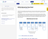
Students have a lot of British rulers to keep track off. This …
Students have a lot of British rulers to keep track off. This Flow Chart allows student a visual of the leaders and then to fill in with important details. There are Google Draw and print copy versions. An answer key is included.
The first lesson of two on Byzantine Empire, students evaluate various sites …
The first lesson of two on Byzantine Empire, students evaluate various sites for a city that is in an ideal location to interact with the three continents bordering the Mediterranean basin. As students examine the local characteristics of the sites, they begin to consider the links between places. Even though the “ownership” of the site of Constantinople (Istanbul) has changed through time, its role as a crossroads has remained constant. Key questions: How does the location of Constantinople influence its ability to interact with the rest of the world? Why is Constantinople a strategic location?
This is the second lesson of two on the Byzantine Empire. Throughout …
This is the second lesson of two on the Byzantine Empire. Throughout the course of world history, borders have changed as various groups of people competed to control and rule territory and acquire resources. Throughout time, empires have expanded and collapsed. The Byzantine Empire once occupied the eastern portion of the Roman Empire with Constantinople as its capital, but yet disappeared from the map in 1453 when Constantinople became the capital of Ottoman Empire. Through an investigation of a series of map layers and examination of an interactive Web site, students discover how and why the borders of the Byzantine Empire changed through time. Key questions: What factors influence border changes? What are the effects of changing borders?
No restrictions on your remixing, redistributing, or making derivative works. Give credit to the author, as required.
Your remixing, redistributing, or making derivatives works comes with some restrictions, including how it is shared.
Your redistributing comes with some restrictions. Do not remix or make derivative works.
Most restrictive license type. Prohibits most uses, sharing, and any changes.
Copyrighted materials, available under Fair Use and the TEACH Act for US-based educators, or other custom arrangements. Go to the resource provider to see their individual restrictions.