Updating search results...

Search Resources

31 Results

View
Selected filters:
  • map
Assessing the Situation
Read the Fine Print
Educational Use
Rating
0.0 stars

Finding themselves in the middle of the Amazon rainforest after a plane crash, students use map scales, keys, and longitude and latitude coordinates to figure out where they are. Then they work in groups to generate ideas and make plans. They decide where they should go to be rescued, the distance to that location, the route to take, and make calculations to estimate walking travel time.

Subject:
Science
Scientific and Engineering Practices
Material Type:
Activity/Lab
Provider:
TeachEngineering
Provider Set:
TeachEngineering
Date Added:
09/18/2014
By Land, Sea or Air
Read the Fine Print
Educational Use
Rating
0.0 stars

In this lesson, students learn that navigational techniques change when people travel to different places land, sea, air and in space. For example, an explorer traveling by land uses different methods of navigation than a sailor or an astronaut.

Subject:
Science
Scientific and Engineering Practices
Material Type:
Activity/Lab
Lesson Plan
Provider:
TeachEngineering
Provider Set:
TeachEngineering
Author:
Denise Carlson
Denise W. Carlson
Malinda Schaefer Zarske
Matt Lippis
Penny Axelrad
Date Added:
09/18/2014
Carry the Continents
Conditional Remix & Share Permitted
CC BY-NC
Rating
0.0 stars

In this activity, students will learn to identify the 7 continents by name and location through song activity blending active learning.  Students will learn facts pertaining to each continent and practice syllable breaking strategies. 

Subject:
Cross-Curricular
English
Health Education
Physical Education
Social Sciences
Material Type:
Activity/Lab
Author:
Robin Shepherd
Date Added:
09/07/2023
The Crash Scene
Read the Fine Print
Educational Use
Rating
0.0 stars

In this lesson, students find their location on a map using Latitude and Longitudinal coordinates. They determine where they should go to be rescued and how best to get there.

Subject:
Science
Scientific and Engineering Practices
Material Type:
Activity/Lab
Lesson Plan
Provider:
TeachEngineering
Provider Set:
TeachEngineering
Date Added:
09/18/2014
Digital Mapping and Geographic Information Systems (GIS)
Read the Fine Print
Educational Use
Rating
0.0 stars

Geographic information systems (GIS), once used predominantly by experts in cartography and computer programming, have become pervasive in everyday business and consumer use. This unit explores GIS in general as a technology about which much more can be learned, and it also explores applications of that technology. Students experience GIS technology through the use of Google Earth on the environmental topic of plastics in the ocean in an area known as the Great Pacific Garbage Patch. The use of this topic in GIS makes the unit multidisciplinary, incorporating the physics of ocean currents, the chemistry associated with pollutant degradation and chemical sorption to organic-rich plastics, and ecological impact to aquatic biota.

Subject:
Science
Scientific and Engineering Practices
Material Type:
Full Course
Unit of Study
Provider:
TeachEngineering
Provider Set:
TeachEngineering
Author:
Andrey Koptelov
Nathan Howell
Date Added:
09/18/2014
France map Quiz
Conditional Remix & Share Permitted
CC BY-NC
Rating
0.0 stars

In this quiz, students will label some mountains, rivers, and cities in France.

Subject:
French
Material Type:
Homework/Assignment
Author:
Chelsea Rowe
Date Added:
03/25/2021
France map activity
Conditional Remix & Share Permitted
CC BY-NC
Rating
0.0 stars

In this activity, students will label some mountains, rivers, and cities in France.

Subject:
French
Material Type:
Homework/Assignment
Author:
Chelsea Rowe
Date Added:
03/25/2021
Getting to the Point
Read the Fine Print
Educational Use
Rating
0.0 stars

In this lesson, students learn how to determine location by triangulation. We describe the process of triangulation and practice finding your location on a worksheet, in the classroom, and outdoors.

Subject:
Science
Scientific and Engineering Practices
Material Type:
Activity/Lab
Lesson Plan
Provider:
TeachEngineering
Provider Set:
TeachEngineering
Author:
Janet Yowell
Malinda Schaefer Zarske
Matt Lippis
Penny Axelrad
Date Added:
09/18/2014
Graph Theory in Drama
Read the Fine Print
Educational Use
Rating
0.0 stars

Students use graph theory to create social graphs for their own social networks and apply what learn to create a graph representing the social dynamics found in a dramatic text. Students then derive meaning based on what they know about the text from the graphs they created. Students learn graph theory vocabulary, as well as engineering applications of graph theory.

Subject:
Science
Scientific and Engineering Practices
Material Type:
Lesson Plan
Provider:
TeachEngineering
Provider Set:
TeachEngineering
Author:
Brian Sandall
Ramsey Young
Date Added:
09/18/2014
Graphing Your Social Network
Read the Fine Print
Educational Use
Rating
0.0 stars

Students analyze their social networks using graph theory. They gather data on their own social relationships, either from Facebook interactions or the interactions they have throughout the course of a day, recording it in Microsoft Excel and using Cytoscape (a free, downloadable application) to generate social network graphs that visually illustrate the key persons (nodes) and connections between them (edges). The nodes in the Cytoscape graphs are color-coded and sized according to the importance of the node (in this activity, nodes are people in students' social networks). After the analysis, the graphs are further examined to see what can be learned from the visual representation. Students gain practice with graph theory vocabulary, including node, edge, betweeness centrality and degree on interaction, and learn about a range of engineering applications of graph theory.

Subject:
Science
Scientific and Engineering Practices
Material Type:
Activity/Lab
Provider:
TeachEngineering
Provider Set:
TeachEngineering
Author:
Brian Sandall
Ramsey Young
Date Added:
09/18/2014
Habitat Mapping
Read the Fine Print
Educational Use
Rating
0.0 stars

The marine environment is unique and requires technologies that can use sound to gather information since there is little light underwater. The sea-floor is characterized using underwater sound and acoustical systems. Current technological innovations are allowing scientists to further understand and apply information about animal locations and habitat. Remote sensing and exploration with underwater vehicles allows scientists to map and understand the sea floor, and in some cases, the water column. In this lesson, the students will be shown benthic habitat images produced by GIS. These imaged will lead to a class discussion on why habitat mapping is useful and how current technology works to make bathymetry mapping possible. The teacher will then ask inquiry-based questions to have students brainstorm about the importance of bathymetry mapping.

Subject:
Science
Scientific and Engineering Practices
Material Type:
Activity/Lab
Lesson Plan
Provider:
TeachEngineering
Provider Set:
TeachEngineering
Author:
Heather Kerkering
Jonelle Stovall
Kimberly Goetz
Melissa Sanderson
Date Added:
09/18/2014
Instructional Plan: Where Am I?
Conditional Remix & Share Permitted
CC BY-NC
Rating
0.0 stars

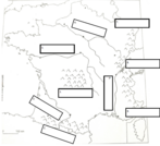
Students will explore the creation, types and uses of maps, the process of map-making and cartography as a career. Students will create a personal map. 

Subject:
Fine Arts
Visual Art
Material Type:
Activity/Lab
Author:
VDOE Fine Arts
Date Added:
08/31/2022
Labeling the 50 States
Unrestricted Use
CC BY
Rating
0.0 stars

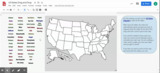
Students will use an Edpuzzle video to label their own map of the United States. The video is structured so students have to pause and label ten states at a time, in alphabetical order. The outcome of this activity is a completed US map for students' later reference. The second activity is a drag and drop game in which students drag labeled states into the appropriate spot on a map of the US. (Note: The state names in the activity have been color-coded according to geographic region. Students and teachers could use this later in the year to discuss regions and state locations.)

Subject:
Geography
History/Social Sciences
Material Type:
Homework/Assignment
Interactive
Author:
Amy Gaulton
Date Added:
07/28/2020
Map That Habitat
Read the Fine Print
Educational Use
Rating
0.0 stars

Historically, seafloor mapping occurred with a simple data collection method: soundings. Soundings are taken by dropping a weight with a pre-measured rope off the side of a boat and noting the measurement on the rope when the weight hits the bottom. In this activity, student teams replicate the creation of seafloor bathymetry by taking a simplified form of soundings of an unseen seafloor model inside a shoebox and translating their collected data into a visualization of the topography, enabling them to better understand and appreciate modern remote sensing.

Subject:
Science
Scientific and Engineering Practices
Material Type:
Activity/Lab
Provider:
TeachEngineering
Provider Set:
TeachEngineering
Author:
Heather Kerkering
Jonelle Stovall
Kimberly Goetz
Melissa Sanderson
Date Added:
10/14/2015
Map-a-Buddy
Read the Fine Print
Educational Use
Rating
0.0 stars

Students are introduced to the concept of tracking and spatial movements of animals in relation to the environments in which they live. Students improve their understanding of animal tracking and how technology is used in this process.

Subject:
Science
Scientific and Engineering Practices
Material Type:
Activity/Lab
Provider:
TeachEngineering
Provider Set:
TeachEngineering
Author:
Heather Kerkering
Jonelle Stovall
Kimberly Goetz
Melissa Sanderson
Date Added:
10/14/2015
Marine Mapping
Read the Fine Print
Educational Use
Rating
0.0 stars

The marine environment is unique and because little light penetrates under water, technologies that use sound are required to gather information. The seafloor is characterized using underwater sound and acoustical systems. Current technological innovations enable scientists to further understand and apply information about animal locations and habitat. Remote sensing and exploration with underwater vehicles enables researchers to map and understand the sea floor. Similar technologies also aid in animal tracking, a method used within science and commercial industries. Through inquiry-based learning techniques, students learn the importance of habitat mapping and animal tracking.

Subject:
Science
Scientific and Engineering Practices
Material Type:
Full Course
Provider:
TeachEngineering
Provider Set:
TeachEngineering
Author:
Heather Kerkering
Jonelle Stovall
Kimberly Goetz
Melissa Sanderson
Date Added:
10/14/2015
NASA eClips Our World:  Where Do Crops Grow?
Unrestricted Use
Public Domain
Rating
0.0 stars

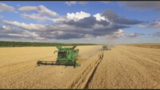
Video Description:  Have you ever wondered where food comes from? Learn how Dr. Catherine Nakalembe uses NASA satellite data to show the health and location of crops around Our World. Maps created from these data help people become more food secure. You can help, too. Using the GLOBE Observer App, you can help scientists validate satellite data by describing land covering through the Adopt a Pixel program.  Video Length:  5:23.    NASA eClipsTM is a suite of online student-centered, standards-based resources that support instruction by increasing STEM literacy in formal and nonformal settings.  These free digital and downloadable resources inform and engage students through NASA-inspired, real-world connections.NASA eClips Our World videos (grades 3-5) help students understand the differences between science (the natural world) and engineering (the designed world).  These video segments supplement elementary learning objectives not only in science, technology, engineering and mathematics, but also in reading, writing, visual and performing arts. 

Subject:
Agricultural Education
Algorithms and Programming
Data and Analysis
Earth Resources
Impacts of Computing
STEM/STEAM
Science
Material Type:
Visual Media
Author:
Betsy McAllister
Date Added:
01/19/2022
NASA eClips Real World:  Close Encounters with an Asteroid
Unrestricted Use
Public Domain
Rating
0.0 stars

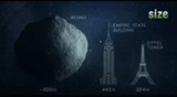
Video Description:  Picture this. NASA sends a spacecraft to land on an asteroid, grab a piece of that asteroid, and then send that sample back to Earth to study. Learn more about all that NASA can learn about the formation of the Solar System from the close encounter of OSIRIS-REx with near-Earth asteroid Bennu.  Video Length:  3:55.NASA eClipsTM is a suite of online student-centered, standards-based resources that support instruction by increasing STEM literacy in formal and nonformal settings.  These free digital and downloadable resources inform and engage students through NASA-inspired, real-world connections.NASA eClips Real World segments (grades 6-8) connect classroom mathematics to 21st Century careers and innovations.  They are designed for students to develop an appreciation for mathematics through real-world problem solving.

Subject:
Earth and Space Systems
Science
Material Type:
Visual Media
Author:
Betsy McAllister
Date Added:
03/01/2022
Nidy-Gridy
Read the Fine Print
Educational Use
Rating
0.0 stars

Normally we find things using landmark navigation. When you move to a new place, it may take you awhile to explore the new streets and buildings, but eventually you recognize enough landmarks and remember where they are in relation to each other. However, another accurate method for locating places and things is using grids and coordinates. In this activity, students will come up with their own system of a grid and coordinates for their classroom and understand why it is important to have one common method of map-making.

Subject:
Science
Scientific and Engineering Practices
Material Type:
Activity/Lab
Provider:
TeachEngineering
Provider Set:
TeachEngineering
Author:
Janet Yowell
Jeff White
Malinda Schaefer Zarske
Matt Lippis
Penny Axelrad
Date Added:
10/14/2015
Plot Your Course - Navigation
Read the Fine Print
Educational Use
Rating
0.0 stars

In this unit, students learn the very basics of navigation, including the different kinds of navigation and their purposes. The concepts of relative and absolute location, latitude, longitude and cardinal directions are explored, as well as the use and principles of maps and a compass. Students discover the history of navigation and learn the importance of math and how it ties into navigational techniques. Understanding how trilateration can determine one's location leads to a lesson on the global positioning system and how to use a GPS receiver. The unit concludes with an overview of orbits and spacecraft trajectories from Earth to other planets.

Subject:
Science
Scientific and Engineering Practices
Material Type:
Full Course
Provider:
TeachEngineering
Provider Set:
TeachEngineering
Date Added:
10/14/2015