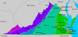
presents a travel itinerary of 58 historic places across Arizona, Colorado, and …
presents a travel itinerary of 58 historic places across Arizona, Colorado, and New Mexico. It includes forts built to protect mail routes and settlers, missions and churches, prehistoric cliff dwellings, trading posts, petroglyphs (from the petrified forest), pit house villages, and Indian villages home to the Anasazi, Sinagua, Zuni, and other Native American tribes.
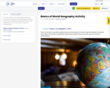
This is an activity to use with students as they are learning …
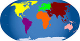
This is an activity to use with students as they are learning how to read a map and decipher continents and oceans. This activity is intended for high school students and can also be used as a check for understanding.
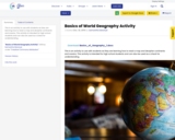
This is an activity to use with students as they are learning …
This is an activity to use with students as they are learning how to read a map and decipher continents and oceans. This activity is intended for high school students and can also be used as a check for understanding.
This is an activity to use with students as they are learning …
This is an activity to use with students as they are learning how to read a map and decipher continents and oceans. This activity is intended for high school students and can also be used as a check for understanding.
In this activity, students will learn to identify the 7 continents by …
In this activity, students will learn to identify the 7 continents by name and location through song activity blending active learning. Students will learn facts pertaining to each continent and practice syllable breaking strategies.
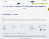
The Did You Feel It (DYFI) Annual Summary Webage and Viewer are …
The Did You Feel It (DYFI) Annual Summary Webage and Viewer are resources that are ideal for Earth Science and Geography laboratiory activitiy.
Students may connect to a database of factual information collected by the USGS on Earthquakes and other seismic disturbances.
The data graphically shows the highest intensity felt at each location searched. The data is grouped into 10 km blocks, and the color of each block corresponds to the highest intensity calculated for that block (regardless of which event).
This jigsaw activity introduces students with Arctic weather data using a role-playing …
This jigsaw activity introduces students with Arctic weather data using a role-playing activity that has students read and interpret graphs while considering the optimal time to plan a research mission to the Arctic.
Each of the 5 countries have topics, real life applications/consequences, and 3-4 …
Each of the 5 countries have topics, real life applications/consequences, and 3-4 artists from that country that can be used a "mentor artists" to lead the students to create an artistic response and presentation for students, staff, and environmental representatives In terms of the art - What do the colors, lines, shapes, and techniques of the artists make you feel? Why did the artist/author decide to use these techniques and colors? What if they had chosen a different color combination?What colors make you feel the same way? What techniques will you use to express the same feeling?
In this activity, students use authentic Arctic climate data to explore albedo …
In this activity, students use authentic Arctic climate data to explore albedo and its relationship to seasonal snowmelt as a self-reinforcing feedback mechanism, which is then applied to large scale global climate change.
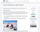
This activity introduces students to the Arctic and Arctic climate. Through a …
This activity introduces students to the Arctic and Arctic climate. Through a virtual exploration of the geography of the Arctic students become familiar with the region. They are then introduced to meteorological parameters that Arctic research teams use.
Students will be able to critically identify key tipping points in the …
Students will be able to critically identify key tipping points in the evolution of political parties. They will be able to connect this evolution to geographic elements and identify causation factors that led to this evolution. Key question: How did political parties impact the geography of the United States between 1792 and 1972? Contains links to student materials and teacher materials for creating lesson plans.
This lesson is similar to a "Mystery Skype" where two classes connect …
This lesson is similar to a "Mystery Skype" where two classes connect through a live video conferencing platform and provide critical thinking clues to determine the location of the other class. Once both locations have been identified, students can then ask additional questions to learn more about the culture, climate, language, and traditions of both classes.
The purpose of this lesson is for students to understand that economic …
The purpose of this lesson is for students to understand that economic activity can be classified as primary, secondary, tertiary, or quaternary; students will define the different levels of economic activity and categorize various activities by its level.
This Story Map Journal centers on World War One. This was a …
This Story Map Journal centers on World War One. This was a conflict on a level never before seen on the planet. Initially, the conflict was largely a European affair until an impressive piece of spy work by the British intelligence community brought the USA into the conflict. Key Questions: How and why did the U.S. become involved in the Great War? How was the United States able to stay out of the war initially? What were the factors that led to the U.S. declaration of war? What were the logistics behind U.S. mobilization? How did the U.S. strategy differ from that of the Allies? How and when did the war end? Contains links to student materials and teacher materials for creating lesson plans.
The Progressive era is typically taught as through the lens that people …
The Progressive era is typically taught as through the lens that people shaped their world in response to the societal problems that came along with the eras of industrialization, urbanization and mass immigration to the United States. This lesson is taught through the lens that geography also shaped reform. Impacts of geography include the growth of Chicago due to its relative location as an intermediary between cattle drives and east coast cities, labor reform including building safety and the geography of buildings and fire exits, and conservative efforts such as the National Parks. This lesson is not meant to teach the entirety of the Progressive era, but a few specific points that were impacted by geography. Contains links to student materials and teacher materials for creating lesson plans.
Demonstrate how to draw a landscape outline using foreground, middle ground and …
Demonstrate how to draw a landscape outline using foreground, middle ground and background. Tell the students that they will need to choose two different VA landscapes to draw including details and color.Draw an outline in pencil of the first regional landscape of your choice.Discuss colored pencil techniques. When coloring in your drawings, use several different colors and shades of a color as well as how to vary the pressure on your pencil to add depth to your drawing. Have students pass out supplies.Students write what two regions of their choice on the back of their first landscape drawing. Students work independently on their first landscape.
This lesson will provide information about the impact technology has on human …
This lesson will provide information about the impact technology has on human activities and lifestyle. It should provide students with an understanding of how the traditional impact of the environment on humans is altered in today’s society by technological advances which allow humans to live beyond the limitations of the environment. Students will brainstorm and provide prior knowledge to lead discussion while the teacher will respond to student input by correcting and adding information as needed. Students will also draw plans for a city and indicate how technology will improve life for the residents.
No restrictions on your remixing, redistributing, or making derivative works. Give credit to the author, as required.
Your remixing, redistributing, or making derivatives works comes with some restrictions, including how it is shared.
Your redistributing comes with some restrictions. Do not remix or make derivative works.
Most restrictive license type. Prohibits most uses, sharing, and any changes.
Copyrighted materials, available under Fair Use and the TEACH Act for US-based educators, or other custom arrangements. Go to the resource provider to see their individual restrictions.