This exercise provides a case study of Danville, Virginia’s economic and demographic …
This exercise provides a case study of Danville, Virginia’s economic and demographic characteristics. Using a geographic information system students are presented with numerous opportunities to extend and refine their map interpretation skills. This story map is not intended to be used as a stand-alone lesson, but portions could be used throughout various units to provide a case study example of key geographic concepts and analysis of the cultural landscape and urban patterns.
This article from the Virginia Geographer assists teachers to understand the geographic …
This article from the Virginia Geographer assists teachers to understand the geographic theme of region. It applies the region concept to the study of Virginia that goes well beyond the Virginia Standards of Learning limited use of landform regions. Region concept is applied to a number of human systems including transportation, economic, and urban systems.
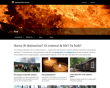
Using this lesson plan students will be more aware of how plants …
Using this lesson plan students will be more aware of how plants and animals adapt to wildland fire. They will: Discuss the adaptive strategies of plants and animals to survive fire. Observe plants and animals in your local area. Design a plant or animal that is adapted for fire survival.
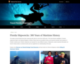
This is a travel itinerary featuring 13 historic shipwrecks in waters near …
This is a travel itinerary featuring 13 historic shipwrecks in waters near Florida, a convergence point for maritime trade routes. Learn about the historical significance of these 13 shipwrecks. See photos and an essay on Florida maritime history.
This research project focused on food access and its implications for food …
This research project focused on food access and its implications for food security and food justice in Newport News’ Southeast Community, a neighborhood marked by high levels of food insecurity and decades of racial segregation and economic divestment. Objectives were threefold: (1) to map the complex socio-spatial networks of food access in a region characterized by high levels of food insecurity; (2) to identify core barriers to food access in the study area, and to better understand how, exactly, these barriers affect food security; and (3) to use this understanding to identify potential policy solutions that could improve local and regional food access and food security.
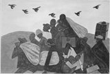
The decades between the banning of the international slave trade in 1808 …
The decades between the banning of the international slave trade in 1808 and the abolition of slavery during the Civil War saw the massive and harrowing relocation of approximately 850,000 enslaved men, women, and children. While some enslaved people were moved when their owners relocated to the western frontier, about two-thirds were bought and sold in America’s slave market. They were forcibly uprooted from their homes, separated from their loved ones, and marched and shipped across the South on railroads and steamships.
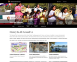
At all points in its history, a significant proportion of the population …
At all points in its history, a significant proportion of the population of the United States had been born in other countries and regions. This being the case, American history can never be understood by just looking within its borders. The culture and politics of the US have always been profoundly shaped by the material and emotional ties many of its residents have had to the places where they were born. This map will allow you to begin to explore those connections at the basic level of demographic statistics.
This information-gap card activity on Forests is based off on Jeff Zwiers’ authentic speaking and listening. This is …
This information-gap card activity on Forests is based off on Jeff Zwiers’ authentic speaking and listening. This is a great activity to get the students to speak and gain a better understanding of the topic instead of just writing down notes.
Presentation of list of resources available to educators through the Virginia Geographic …
Presentation of list of resources available to educators through the Virginia Geographic Alliance, National Geographic, and New American History Project
Presentation by Mary Finley-Brook is on climate justice and the research work …
Presentation by Mary Finley-Brook is on climate justice and the research work she has done in Newport News. The economically depressed south end of Newport News is particularly vulnerable to environmental toxins from the nearby shipyard, coal terminal, and interstate highway that transects their neighborhood.
Students will be able to critically identify key tipping points in the …
Students will be able to critically identify key tipping points in the evolution of political parties. They will be able to connect this evolution to geographic elements and identify causation factors that led to this evolution. Key question: How did political parties impact the geography of the United States between 1792 and 1972? Contains links to student materials and teacher materials for creating lesson plans.
This lesson is similar to a "Mystery Skype" where two classes connect …
This lesson is similar to a "Mystery Skype" where two classes connect through a live video conferencing platform and provide critical thinking clues to determine the location of the other class. Once both locations have been identified, students can then ask additional questions to learn more about the culture, climate, language, and traditions of both classes.
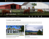
The Grant-Kohrs Ranch commemorates America's frontier cattle era. The ranch, located north …
The Grant-Kohrs Ranch commemorates America's frontier cattle era. The ranch, located north of Yellowstone in Deer Lodge, Montana, is among the best surviving examples of an economic strategy based on the western cattle industry of the 1850s-1970s. A German immigrant, Conrad Kohrs, purchased the ranch in 1866 and began by supplying to mining camp butcher shops.
The student will apply social science skills to understand how the nation …
The student will apply social science skills to understand how the nation grew and changed from the end of Reconstruction through the early twentieth century by e) evaluating and explaining the social and cultural impact of industrialization, including rapid urbanization; Great Migration.
presents 26 historic places?barns, civic buildings, churches, railroad depots, schools, and libraries?that depict the history of this county, known as the Heart of the Heartland.
offers educators Park Service resources that help teach about our nation's cultural …
offers educators Park Service resources that help teach about our nation's cultural heritage, and which look at how the NPS is protecting and preserving them. Subjects include archaeology, historic buildings and structures, mapping, military history, and national historic landmarks. The resources may be in the form of learning programs, case studies, lesson plans, teachers' handbooks, and more.
No restrictions on your remixing, redistributing, or making derivative works. Give credit to the author, as required.
Your remixing, redistributing, or making derivatives works comes with some restrictions, including how it is shared.
Your redistributing comes with some restrictions. Do not remix or make derivative works.
Most restrictive license type. Prohibits most uses, sharing, and any changes.
Copyrighted materials, available under Fair Use and the TEACH Act for US-based educators, or other custom arrangements. Go to the resource provider to see their individual restrictions.