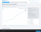
List of countries with their annual methane emissions. The data are from …
List of countries with their annual methane emissions. The data are from 2005. The data are given in total annual emissions, thus must be compared with economic activity, geographic and most importantly, population data to be relevant.
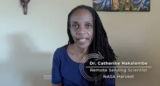
Video Description: In this close-up video, Dr. Catherine Nakalembe, Remote Sensing Scientist for …
Video Description: In this close-up video, Dr. Catherine Nakalembe, Remote Sensing Scientist for NASA Harvest, shares her passion for helping farmers around the world through the use of NASA satellites to monitor crops from space to increase sustainability. She also describes how her love for hiking, photography, and travel supports her work. Video Length: 2:09.NASA eClipsTM is a suite of online student-centered, standards-based resources that support instruction by increasing STEM literacy in formal and nonformal settings. These free digital and downloadable resources inform and engage students through NASA-inspired, real-world connections.NASA eClips Ask SME: Close-up with a NASA Subject Matter Expert videos are professionally developed to capture a glimpse of NASA SME's personal interests and career journeys. Each can be used to spark student interest and broaden their ideas of the STEM workforce. Additional videos in this series can be found by searching GoOpenVA using "NASA eClips Ask SME".
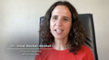
Video Description: In this close-up video, Dr. Inbal Becker-Reshef, Program Director for NASA …
Video Description: In this close-up video, Dr. Inbal Becker-Reshef, Program Director for NASA Harvest, describes her journey and how her travels as a child helped her choose a career in science over her passion for art. She shares how cameras on satellites provide data to help farmers and agricultural leaders grow more food and work toward food security worldwide. Video Length: 2:21.NASA eClipsTM is a suite of online student-centered, standards-based resources that support instruction by increasing STEM literacy in formal and nonformal settings. These free digital and downloadable resources inform and engage students through NASA-inspired, real-world connections.NASA eClips Ask SME: Close-up with a NASA Subject Matter Expert videos are professionally developed to capture a glimpse of NASA SME's personal interests and career journeys. Each can be used to spark student interest and broaden their ideas of the STEM workforce. Additional videos in this series can be found by searching GoOpenVA using "NASA eClips Ask SME".
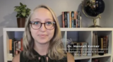
Video Description: In this close-up video, Dr. Hannah Kerner, Artificial Intelligence Lead at …
Video Description: In this close-up video, Dr. Hannah Kerner, Artificial Intelligence Lead at NASA Harvest, shares her experiences in writing code and developing machine learning algorithms that enable NASA satellites to monitor where food is being grown. She describes how her hobbies of hiking, scuba diving, and volunteering intersect with her work. Video Length: 2:28.NASA eClipsTM is a suite of online student-centered, standards-based resources that support instruction by increasing STEM literacy in formal and nonformal settings. These free digital and downloadable resources inform and engage students through NASA-inspired, real-world connections.NASA eClips Ask SME: Close-up with a NASA Subject Matter Expert videos are professionally developed to capture a glimpse of NASA SME's personal interests and career journeys. Each can be used to spark student interest and broaden their ideas of the STEM workforce. Additional videos in this series can be found by searching GoOpenVA using "NASA eClips Ask SME".
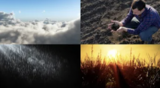
Video Description: Have you ever wondered where food comes from? Learn how …
Video Description: Have you ever wondered where food comes from? Learn how Dr. Catherine Nakalembe uses NASA satellite data to show the health and location of crops around Our World. Maps created from these data help people become more food secure. You can help, too. Using the GLOBE Observer App, you can help scientists validate satellite data by describing land covering through the Adopt a Pixel program. Video Length: 5:23. NASA eClipsTM is a suite of online student-centered, standards-based resources that support instruction by increasing STEM literacy in formal and nonformal settings. These free digital and downloadable resources inform and engage students through NASA-inspired, real-world connections.NASA eClips Our World videos (grades 3-5) help students understand the differences between science (the natural world) and engineering (the designed world). These video segments supplement elementary learning objectives not only in science, technology, engineering and mathematics, but also in reading, writing, visual and performing arts.
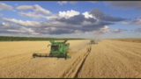
NASA eClips Real World: Food Security -- Monitoring Crops from SpaceVideo Description: Discover …
NASA eClips Real World: Food Security -- Monitoring Crops from SpaceVideo Description: Discover how NASA's Earth-observing satellites gather data to monitor food growth. Dr. Inbal Becker-Reshef describes how mathematics is used to interpret satellite data and describe vegetation and crop yield. Dr. Hannah Kerner shares how algorithms and models use NASA data to describe and predict food supply and food shortages. This work through NASA Harvest provides tools for farmers and governments to describe and predict food security worldwide. Video Length: 5:25.NASA eClipsTM is a suite of online student-centered, standards-based resources that support instruction by increasing STEM literacy in formal and nonformal settings. These free digital and downloadable resources inform and engage students through NASA-inspired, real-world connections.NASA eClips Real World segments (grades 6-8) connect classroom mathematics to 21st Century careers and innovations. They are designed for students to develop an appreciation for mathematics through real-world problem solving.
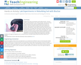
Students learn about soil properties and the effect biochar—charcoal used as a …
Students learn about soil properties and the effect biochar—charcoal used as a soil amendment—has on three soil types, sand, loam and clay. They test the soils’ water retention capability before and after the addition of biochar. During the activity, student teams prepare soil mixtures, make observations (including microscopic examinations), compare soil properties, conduct water retention tests, take and record measurements, and analyze their observations and data. They see how the physical properties of soils—color, texture, and particle size—can be indicators of nutrient content and water retention capabilities to support plant growth. From their findings, they consider biochar’s potential benefits for environmental and agricultural applications, especially in conditions of drought and depleted soils. An activity lab sheet is provided to guide experimental data collection and analysis.
Over the course of three sessions, students act as agricultural engineers and …
Over the course of three sessions, students act as agricultural engineers and learn about the sustainable pest control technique known as soil biosolarization in which organic waste is used to help eliminate pests during soil solarization instead of using toxic compounds like pesticides and fumigants. Student teams prepare seed starter pots using a source of microorganisms (soil or compost) and “organic waste” (such as oatmeal, a source of carbon for the microorganisms). They plant seeds (representing weed seeds) in the pots, add water and cover them with plastic wrap. At experiment end, students count the weed seedlings and assess the efficacy of the soil biosolarization technique in inactivating the weed seeds. An experiment-guiding handout and pre/post quizzes are provided.
Students identify Virginia's major agricultural products and where they are grown with …
Students identify Virginia's major agricultural products and where they are grown with an online GIS. The They will explain the effects of agriculture on Virginia's economy. Contains links for primary source data related to Virginia agriculture. GeoInquiries are short, standards-based inquiry activities for teaching map-based content found in commonly used textbooks.
This activity introduces the idea of cyberbiosecurity in the context of a …
This activity introduces the idea of cyberbiosecurity in the context of a "clue" style activity focused on vulnerabilities in the U.S. food system. It can be facilitated in 60 minutes, either in a single session or 3-4 shorter sessions. This activity is part of the Agricultural Cyberbiosecurity Education Resource Collection that contains resources for formal and non-formal agricultural educators working with middle school aged youth. Published as Open Educational Resources, all resources are provided in durable (pdf) and customizable (MS Word) formats. They are hosted on GoOpenVA in a unique resource collection, Ag Cybersecurity Virginia Tech, at https://goopenva.org/curated-collections/143 and on on Virginia Tech’s stable repository, VTechWorks at https://doi.org/10.21061/cyberbiosecurity
No restrictions on your remixing, redistributing, or making derivative works. Give credit to the author, as required.
Your remixing, redistributing, or making derivatives works comes with some restrictions, including how it is shared.
Your redistributing comes with some restrictions. Do not remix or make derivative works.
Most restrictive license type. Prohibits most uses, sharing, and any changes.
Copyrighted materials, available under Fair Use and the TEACH Act for US-based educators, or other custom arrangements. Go to the resource provider to see their individual restrictions.