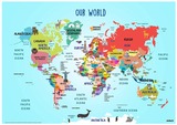
This Coding lesson plan is a resource used to review continents and …
This Coding lesson plan is a resource used to review continents and oceans and VA's location on World map. It also contains several links to review geographic vocabulary using Quizlet , links to access SOLPASS games and a "How to code with SCRATCH" video along with a SCRATCH link with a ready made digital map to use for modeling code or to allow students to copy/remix the code to fit their needs.
This resource includes a student HyperDoc and associated "apply" task to ensure …
This resource includes a student HyperDoc and associated "apply" task to ensure student understanding.Title: Allusion & Figurative Language LessonTopic: Literary Allusion & Figurative LanguageEducational Standards: SOL 9.3.eSubject Area: English 9
The goal of this exercise is to compare people's attitudes about the …
The goal of this exercise is to compare people's attitudes about the American Dream with their experiences of upward mobility at the turn of the 21st century. Crosstabulation will be used.
The goal of this exercise is to explore the relationship between social …
The goal of this exercise is to explore the relationship between social identity and attitudes toward out-group members. Frequency distributions, crosstabulations, correlations, and multiple regression will be used.
In this learning experience, the students will complete a primary source inquiry …
In this learning experience, the students will complete a primary source inquiry into the impacts of Reconstruction on Black experiences in Virginia and the South. The students will use the Claim-Evidence-Reasoning structure to defend one of two claims.Students will analyze sources that depict/detail Black experiences and perspectives before, during, and after the Reconstruction. This learning experience will be most effective after students have been introduced to the what and when of Reconstruction.
piggy backing on lesson number 1, this allows students the opportunity to …
piggy backing on lesson number 1, this allows students the opportunity to try to record their code with arrows, paying close attention to the sequence.
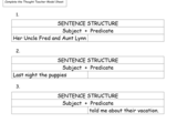
This is a follow-up lesson after the students understand a complete sentence …
This is a follow-up lesson after the students understand a complete sentence and its parts (subject and predicate). Students will add missing subjects or predicates to make complete sentences. Students will begin the sentences with capital letters and end them with punctuation marks. This mini-lesson follows the "I DO, WE DO, YOU DO" approach.
In the second lesson of four on Ancient Greece, students refine their …
In the second lesson of four on Ancient Greece, students refine their knowledge of physical features as they investigate pictures of Greece and determine how a particular physical feature influenced human action. Key question: How did the physical geography of the Aegean basin shape the economic, social and political development of Greek civilization?
In the first lesson of four on Ancient Greece, students use geographic …
In the first lesson of four on Ancient Greece, students use geographic terms such as hemispheres, continents, and direction to describe the relative location of Greece within the world, within Europe, and within the Aegean Basin. In addition, students extend and refine their ability to identify various types of physical features on maps at a variety of scales. Students examine maps to identify and describe the physical environment of Greece. Key questions: Where is ancient Greece located?; What are physical features of the Aegean Basin?; How did the location of Greece and its physical environment influence its interaction with the rest of the world?
In the last lesson of four on Ancient Greece, students employ spatial …
In the last lesson of four on Ancient Greece, students employ spatial thinking to understand the extent of the empire of Alexander the Great by examining and comparing visuals and maps. Key question: How does the geographic extent of an empire influence its ability to exist through time?
In the first of two lessons on ancient river valley civilization, students …
In the first of two lessons on ancient river valley civilization, students examine the physical environment of the early river valley civilizations. After identifying the locations of the ancient civilizations, students complete a feature analysis to assist them in comparing the physical environments and determining how it afforded protection to the civilizations. Key questions: Why was a river valley a good place for a settlement? What was the significance of these river valley civilizations?
In the second of two lessons on ancient river valley civilizations, students …
In the second of two lessons on ancient river valley civilizations, students examine the physical environment of the early river valley civilizations. Moving water carries and sorts sediment, changes landforms, and creates strata. The sediment becomes the base for soil formation, and it is the material of which flood plains, deltas, and natural levees are built. Through a demonstration of the sedimentation process, students will come to understand the significance of the process and seasonal flooding to agricultural activity in the early river valley civilizations. Key questions: How does the process of sedimentation affect soil fertility? Why are some river valleys good sites for human settlement?
The first lesson of two on Ancient Rome, students examine physical maps …
The first lesson of two on Ancient Rome, students examine physical maps of Rome to identify physical features that provided security for the site of Rome. In addition, students examine the relative location of Rome and its connections within the Mediterranean Basin and beyond. The second segment of the lesson examines the expansion of the Roman Empire through time and the role of physical features in facilitating or hindering that expansion. Key questions: What are the physical features of Rome?; How did the physical geography of Rome influence its development?
The second lesson of two on Ancient Rome, students examine the geographic …
The second lesson of two on Ancient Rome, students examine the geographic extent of the Roman Empire. The Orbis Web site, hosted by Stanford University, provides a map of the Roman Empire at its largest extent with the locations of key cities and transportation links. Key questions: How were places within the Roman Empire connected?; How did time and distance affect interactions within the Roman Empire?
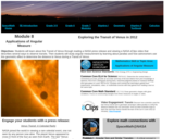
Students will learn about the Transit of Venus through reading a NASA …
Students will learn about the Transit of Venus through reading a NASA press release and viewing a NASA eClips video that describes several ways to observe transits. Then students will study angular measurement by learning about parallax and how astronomers use this geometric effect to determine the distance to Venus during a Transit of Venus. This activity is part of the Space Math multimedia modules that integrate NASA press releases, NASA archival video, and mathematics problems targeted at specific math standards commonly encountered in middle school textbooks. The modules cover specific math topics at multiple levels of difficulty with real-world data and use the 5E instructional sequence.
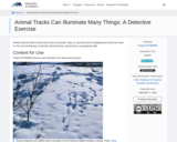
Having students follow animal tracks (even just people, dogs, or squirrels) and …
Having students follow animal tracks (even just people, dogs, or squirrels) and investigating how tracks are made is a fun and exciting way to develop critical thinking, measurement, and graphing skills.
In this lesson, students explore the importance of albedo (or reflectivity) to …
In this lesson, students explore the importance of albedo (or reflectivity) to penguins and the surfaces they inhabit and learn how penguin colonies may be mapped using satellites.
Students will use their five senses to describe the three different types of apples using …
Students will use their five senses to describe the three different types of apples using the words from the word bank. Afterwards students will conduct a short survey to find out which apple was liked by most students. The results will be shown by drawing a pictograph.
No restrictions on your remixing, redistributing, or making derivative works. Give credit to the author, as required.
Your remixing, redistributing, or making derivatives works comes with some restrictions, including how it is shared.
Your redistributing comes with some restrictions. Do not remix or make derivative works.
Most restrictive license type. Prohibits most uses, sharing, and any changes.
Copyrighted materials, available under Fair Use and the TEACH Act for US-based educators, or other custom arrangements. Go to the resource provider to see their individual restrictions.